

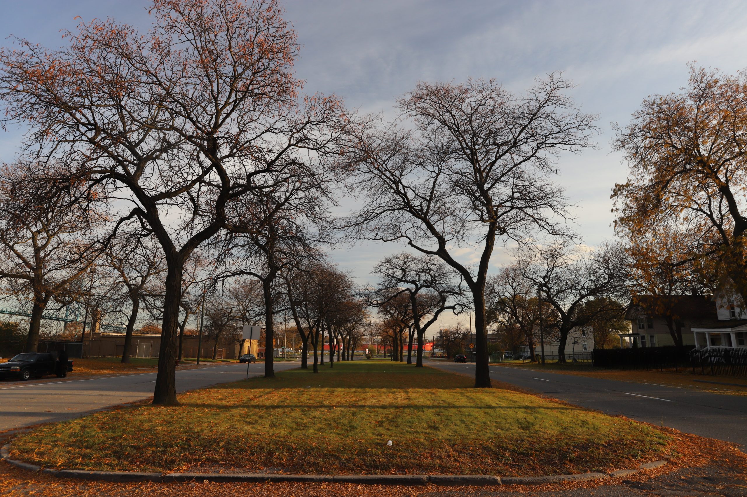
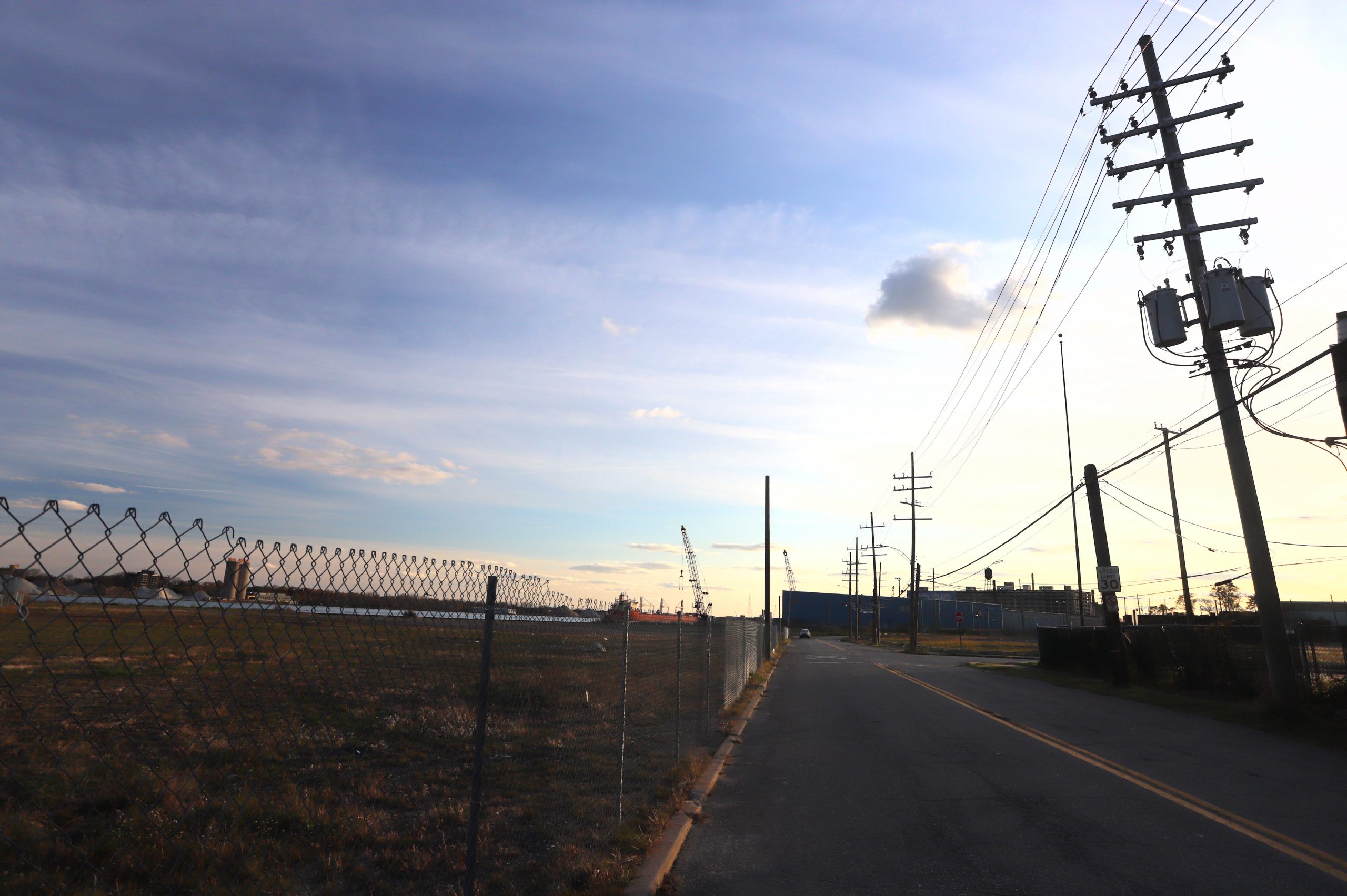
The other day (awhile ago, sorry about the delay), I deviated from my morning routine and took the hound down by the river. I greeted a parishioner entering the prosperity theology church, outside which a Challenger and a Caravan with custom modifications were illegally parked across crosswalks. Crossing some police tumult at Fort Street, where several cops shrugged at a caravan of cars driving the wrong way north on Grand Boulevard, whilst supervising the taping off of a door at the Crest Motel, we crossed into the elegant, tree-lined median and trudged south.
It was overcast. The day of the Free Press Marathon, and overhead soared a plane advertising a Chevrolet dealership, because trucks. What a time to be alive!

TOWARD THE RIVERFRONT
The industrial corridor of Fort Street (and the highway) is a solid edge to Southwest’s more residential neighborhoods. Not a whole lot of residential structures south of Fort, though Grand makes an attempt.
The new riverfront dog/skate park are pretty nice and a welcome addition to the neighborhood. The dog park was built on top of some sort of toxic soil covered over with a bunch of clay and then clean soil. The grass is green and trees are growing, and the pups tussle and bark whilst the skaters skate. One day, allegedly, the riverfront trail will continue down this-a-way. It has been rumored that the Gordie Howe Bridge will even have a bike lane, though I don’t believe a word of it!
As Jack Dog snurfed his way across torn up sidewalks, strewn with glass and debris, I found myself wondering what the hell the plan is for all of this space so close to increasingly valuable real estate markets of Southwest, Corktown, and Downtown. Shockingly, a bunch of them are owned by our man Moroun. You don’t say! It is unlikely that they would factor into the geriatric obstructionist’s longtime goal of building what I call “Ambassador Bridge ‘Too,'” because they’re so far away from the bridge.
The Moroun Imperium has long coveted the idea of a replacement for the agéd, 1929 structure. They even went so far as to build an approach for the new bridge, skirting the permitting process. When you’re a billionaire in a dying city, permission is given often, forgiveness by universal default. Someone needs to convince the dude that Ambassador Bridge “Too,” much like “fetch,” is not happening. Stop trying to make it happen, Matty! (I recently mused on the Bridge’s 90th birthday and some ideas for its future.)
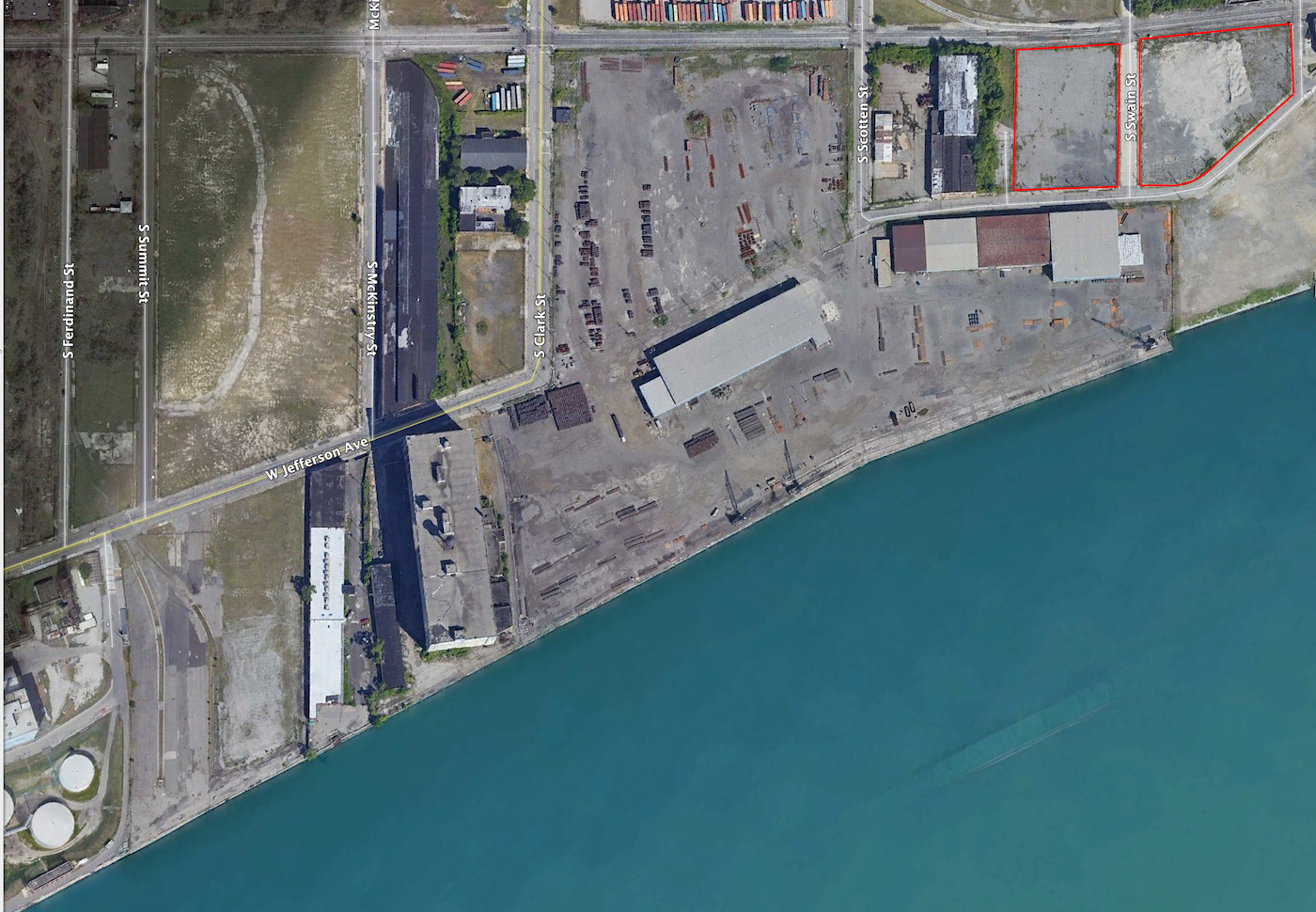
I found a few lots. They’re not technically surface parking lots, but they are vacant, and there were cars parked on them when I was there. They’re also near enough to prime real estate that I think we should develop them.
In the great white gentrifying spirit of renaming neighborhoods, we’ll call this Morounville. If Gilbert and Ilitch have their own villes, why not create one for The Ambassador himself? This would seem better than “West Side Industrial,” the current “official” name for the adjacent (to the east, really) “neighborhood.”
THE SITES
The first lots I looked at total 8.944 acres and have a total recorded sale value of $985,000. There are a few lots that don’t have recorded sale values listed. This means that either their sales were not recorded because Wayne County’s records are garbage, or some other murky business is going on. Either is possible.
Unsurprisingly, their taxable rate (land value / 2) is less than half of the recorded sale values, meaning Moroun is getting a deal on taxes.
In aggregate, we’ve got 13.051 acres of mostly vacant land (outlined in red below). That’s 569,000 square feet from Fort Street to Jefferson. 2019 equalized value for the total area is $387,200– less than a dollar a square foot of taxable value. Compare this to vacant land downtown: a surface parking lot near Joe Louis is valued at $23.66 per square foot. A lot on Lafayette on the edge of Quickenville is valued at $33.34 per square foot. Even surface lots in Corktown have tax assessments that are 5-10 times the rate of these lots.
That’s bizarre.

But not surprising. During my 45-minute tenure with the building department, it always shocked me that enforcement would go after, say, mom-and-pop businesses for things like temporary signs (sandwich boards, for example, are illegal in the city of Detroit), but would allow all manner of tomfoolery from the Ambassador Bridge crew.
A FOIA request I submitted (after I was mysteriously terminated the day before the end of my probation) to learn the fate of two tickets written to Dennis Kefallinos and the Moroun Empire- was dismissed because “the records in question do not exist.” The records do not exist! (That’s a second Mean Girls reference. Maybe I can see why they got rid of me.)
So, we’ve got some critically undertaxed, critically underdeveloped land. It’s very close to downtown and very close to our closest natural asset, the river. Below the lots in question are highlighted in pink on a roughly-drawn map:
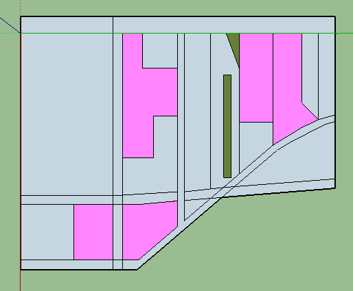
THE PROJECT
Let’s think about the remaining buildings in the neighborhood and what we want to complement. The Detroit Port Terminal. The old railroad buildings. Industry along Fort Street. I would want any new development to honor this architectural heritage rather than, say, building vinyl-sided subdivisions. But not pseudohistorical– I just want to match the general vibe. Grand Boulevard is the only portion of the area with single-family homes, and it includes some apartments as well.
Most buildings will have zero lot lines and maximize density closer to the riverfront with more modest densities closer to Fort Street. I’m thinking about the space subtractively– that is, maximizing the spatial potential and then “deducting” from it, which is in stark contrast to the “additive” model of suburban development, plopping down the lowest-density thing you can on a greenfield space.
Here’s what I came up with:
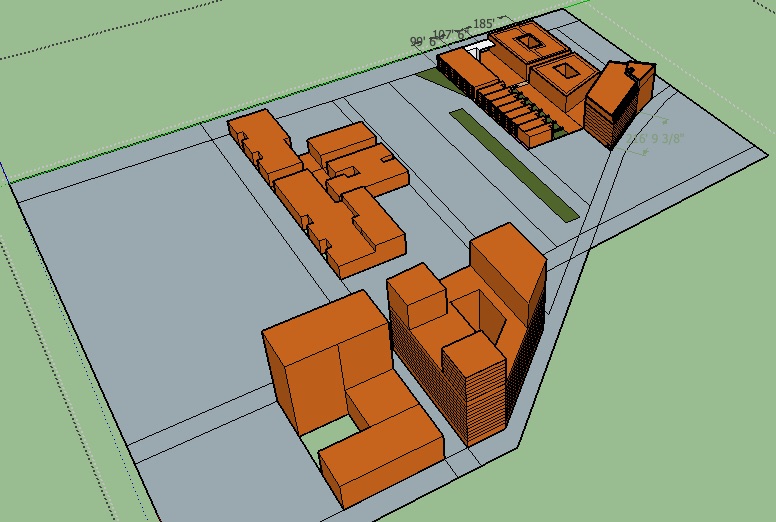
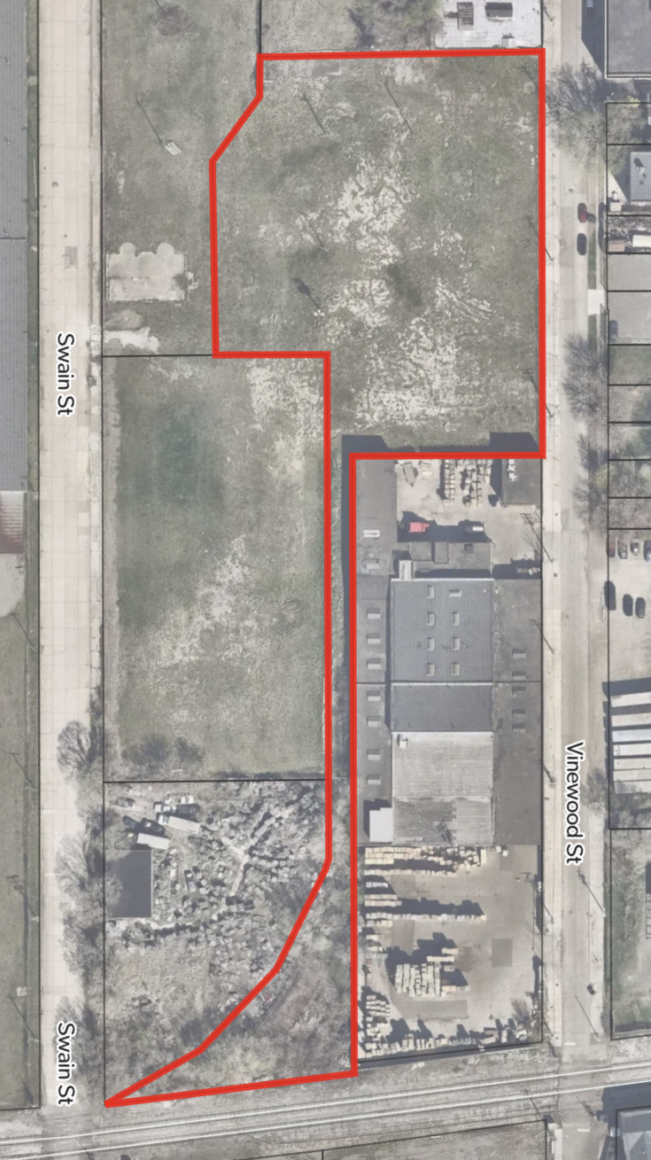
Some napkin pro forma figures that that development costs would run a cool $445 million for the whole project, excluding infrastructure costs. This works out to eleven buildings, with floor-area-ratios ranging from a low of 1.70 for the West Fort residences to a high of 11.12 for the Swain East Apartments (the central, three-towered, diagonal chunk in the orange image above).
1. Fort Street Site – North Building: 42,635 s.f. footprint, 197,038 s.f. GFA
2. Fort Street Site – Center Building: 35,479 s.f. footprint, 116,786 s.f. GFA
3. Fort Street Site – Jefferson Building: 36,000 s.f. footprint, 244,000 s.f. GFA
4. Fort – Connecting Frontage: 4,475 s.f. footprint, 11,411 s.f. GFA
5. West Fort Residences: 191,350 s.f. footprint, 325,295 s.f. GFA
6. West Grand Townhouses: 50,344 s.f. footprint, 161,000 s.f. GFA
7. Swain East Apartments: 90,651 s.f. footprint, 1,008,000 s.f. GFA
8. Swain West Apartments: 73,000 s.f. footprint, 508,300 s.f. GFA
To put that amount of money in perspective, $445 million is equivalent to less than two Duggan-sponsored demolition bond issues, or the cost of two tickets and four beers to see the Red Wings lose.
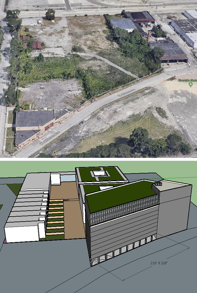
I didn’t get into a granular level of design for these sites, but, based on the cursory layouts in Sketchup, they seem to involve quite a bit of open space, allowing for a healthy flow of foot traffic, and for more development and event traffic along the riverfront in the future.
PARKING CONCERNS
None of my figures include any parking lots to speak of. Plopping down 2,000-4,000 new residents in a small area might well create some traffic problems, so, considering the amalgamated lot that would stretch from Vinewood on the east to include the lot on the west side of Swain, this could be developed into underground parking. A two-story, underground garage could provide 1,284 spaces across a total area of 213,000 square feet. This could provide parking for tenants, residents, commercial visitors, and visitors to the new-and-improved Riverfront park. MoPop West, maybe.
Based on my previous estimates of cost and spatial inefficiency, this would cost $33,384,000. In cost terms, this is equivalent to 232 apartments. Though it represents less than 8% of the total project cost, it may be useful to consider alternatives to plentiful parking:
$33 million could fund, by my estimates, six fully electric buses per hour along Fort Street to cover a round trip distance of about 12 miles, and, let’s, say, another six buses to go up Grand Boulevard every hour (connecting with Vernor and connecting to Midtown via Warren), at a break-even ridership of 60 passengers per hour. Not impossible to imagine that given that this development project would add 2,500-4,000 permanent residents– and accompanying service sector jobs.
ITE figures suggest this project would generate 12,600+ trip ends per day for residential traffic and about 2,700+ trips for commercial space across the projects. If transit accounted for 25% of these trips, that’s more than enough for a break-even on bus routes.

CONCLUSIONS
Beyond development– because we know that’s unlikely: The city should reassess these properties. BSEED should go after the owner with aggressive enforcement. Write them a blight ticket for every styrofoam cup on each lot. Speculation becomes far less valuable when you’re paying $200 in fines every week. And it’d be a hell of a lot better than doing what we’re doing now, treating preferentially wealthy landowners while the city struggles with an epidemic of eviction and foreclosure.
Is it time for a vacancy tax? This would hit absentee owners of especially huge industrial parcels really hard. Really, we should consider anything that can incentivize development. After all, this is enough vacant land to build an entire, new neighborhood with some great river views. Stay tuned for more entries in Detroit Park City.