In the aftermath of a catastrophic flooding event a few weeks ago, Detroiters cleaned out their basements of water-damaged and sewage-soaked debris and wondered: what’s next? There is, of course, always blame to go around. People are understandably quite angry. But it’s not clear that the average administrator or elected official seems to really get the situation. MDOT blamed power outages for losing pumping capacity. But the pumps themselves, they said, were technically working! (“Technically, Doctor, he died of blood loss, not a gunshot wound!”). Certainly, it’s not going to harm the chances of Mayor Mike Duggan, who will inevitably win his coming reëlection in a landslide against a who’s who of nobody candidates. But what’s left after this? We can focus our building– and rebuilding- efforts on transportation infrastructure, which is the key to addressing this issue in the future. And an illustration from my native West Grand Blvd. in Southwest Detroit.
Thinking With, Not Against, Nature
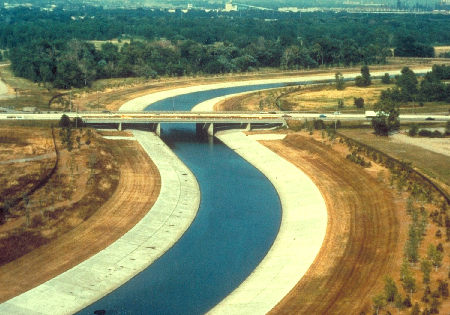
Road networks are not unlike root systems, hydrological systems, or other natural systems that involve organic networks designed to effectively move things between places. The difference is that, unlike natural systems, humans have this unique ability to bypass and even subjugate the natural path of things when we want to. This often backfires, though, resulting in concrete cracking, basements flooding, or what have you. I often go by the maxim that “the house always wins,” in which the “house” is our spaceship earth, or whatever. Water will triumph over whatever is designed by some MDOT engineer, every time. So, don’t try and beat it– try and work or around it. Just not against it.

Less Hardscaping, More Green Space
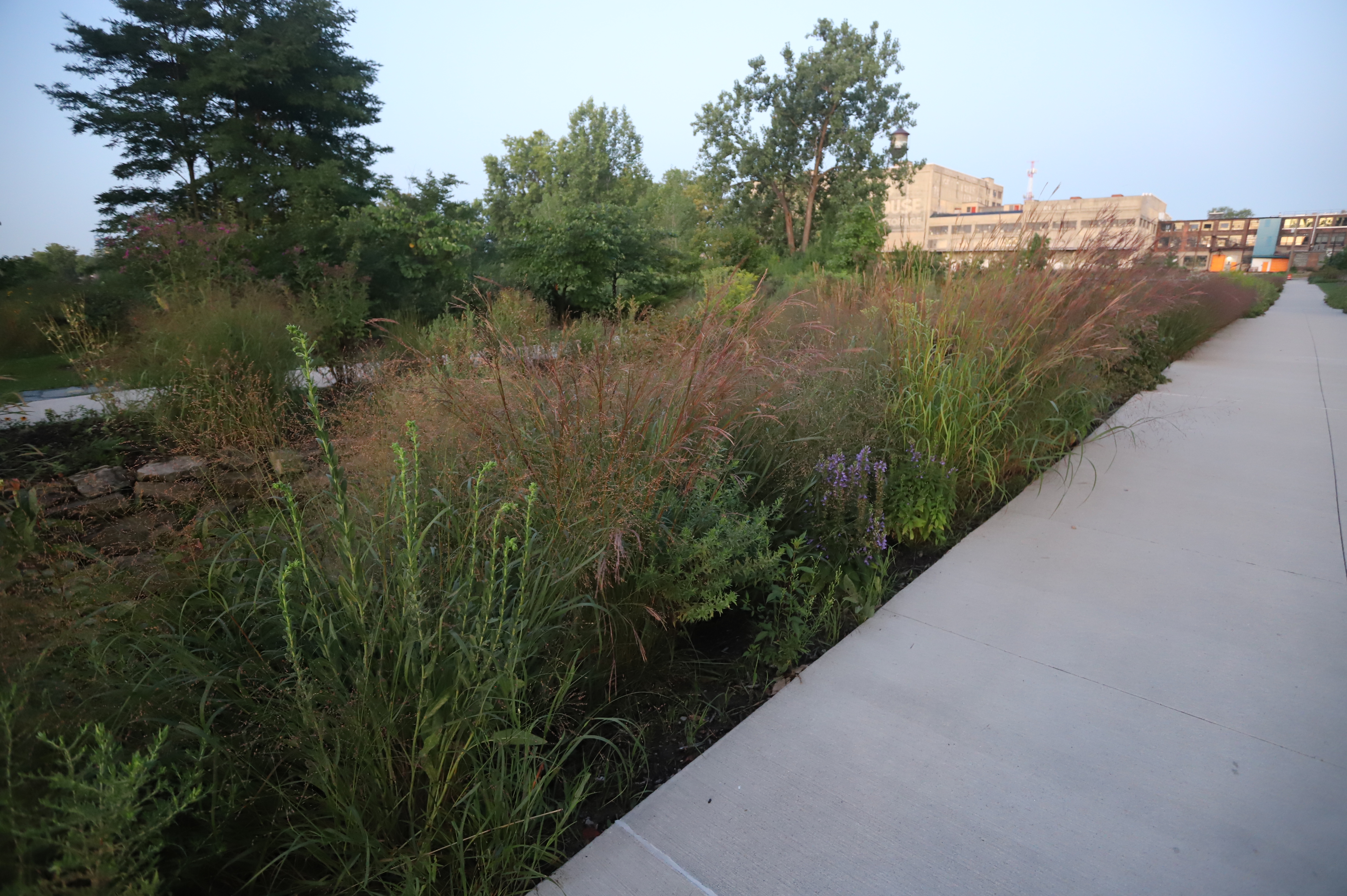
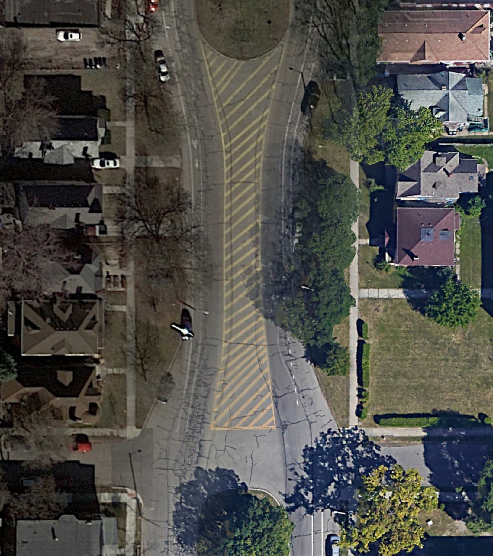
The above example is from West Grand Blvd. in Southwest Detroit. Along with Outer Drive, Grand is one of two streets that goes the whole way around the city in a sort of zigzagging half-circle. Ish. It’s a wide street that usually boasts a median and, in many areas, quite stately, old homes. It’s also one of very few streets in Detroit whose numbering scheme endured after the city’s streets were at some point re-numbered to match the baseline-and-meridian system– so 1500 Vinewood and 1500 Hubbard are the same block as 300 West Grand, or something.
The striped yellow section in the middle? I don’t have any clue, either. It’s about 7000 square feet, so, equivalent to about a regular residential lot and a half. One might think it is designed to allow for trucks to turn around– it is sufficiently large. There are semis that drive down West Grand, mostly because I have no idea. There is some semi-worthy light industry north of Michigan Avenue on Grand (but I’m not sure why they would be taking the boulevard instead of Michigan at that point).
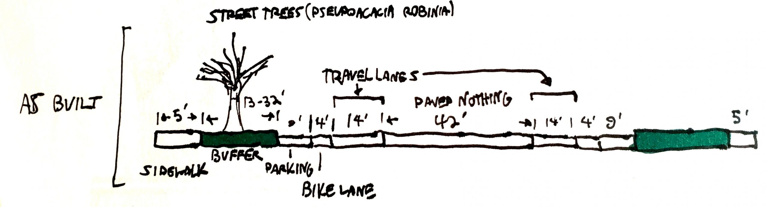

Lots of Street; Not Much Actual Utility.
This section of West Grand is highly conducive to speeding, large truck traffic, and teenage dipshits popping wheelies on dirt bikes at 3am. But I’m not calling the cops, because we know that human behavior is more effectively influenced by design than it is by the threat of state violence. Don’t call 911, call your local city planner, remember? The city has repeatedly declined resident requests to install speed humps on West Grand because of the high rates of traffic from heavier vehicles– ostensibly fire trucks, maybe more like Moroun trucks.
While there are some cultural issues at play– the fact that drivers in Michigan seem to believe that their unimpeded use of the roadway to do whatsoever they wish, no matter how fast or how dangerous- it’s more of a design issue than a people issue. Fast driving is a behavioral issue as well as a design issue, or, rather, an issue in which design can influence behavior. People will slow down– if the design forces them to.
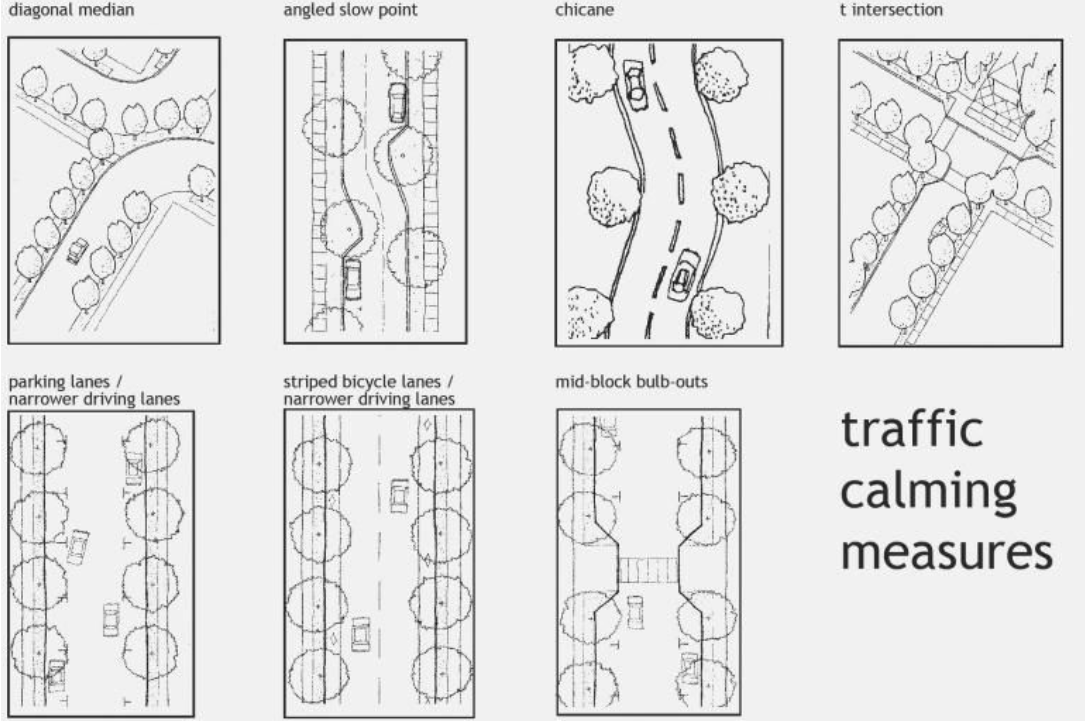
Other design measures to be included
- Traffic Calming. Stop signs should be used as a way to regulate intersections with high rates of left turns, crossing traffic, etc. That said, they’re usually put in place to slow cars, which is not a thing, because people blow through them at 50mph anyway. So, to that end, I’m not a huge fan of stop signs unless they’re absolutely necessary. What I do believe in, however, is things that slow car traffic down. A car is less likely to blow through a bottlenecked area with planted rain gardens on either side. Unless they want to drive the car into a ditch.
- Safer turn zones. Turns account for a large number of accidents, whether car-car, car-pedestrian, or car-cyclist, and it’s largely a matter not of visibility in general, but of cars not being forced to slow down sufficiently and look before turning. The benefit is that in many cases, various bump-outs can integrate stormwater management infrastructure to retain and/or detain stormwater.
Greener Streets, Safer Streets
In conclusion, we’ve got a few benefits here:
[1] Slower, safer traffic. This one is fairly self-explanatory.
[2] Better stormwater management. Reducing incidence of flooding might well save the average household– in a flooding-prone city like Detroit- a couple hundred bucks per year, if we think about how much it costs to clean out a flooded basement, whether or not you’re losing all of your worldly possessions.
[3] Mitigating the urban heat island. Less paved area means less asphalt. Fresh asphalt– our age-old method of building roads by crushing up rocks with a bunch of hot oil in it- has an albedo of around 5-10%. Concrete, which has a much lighter color in its finished format, is several times higher, but it’s less preferable because of how much more expensive it is. Dirt and grass have a lower albedo than concrete, but, along with plants, they also hold water, which concrete and asphalt don’t. But the biggest issue here is the ability to plant things that create shade, reducing ambient summertime temperatures by 10-17°F. This, in turn, reduces summer residential energy usage. Smoother traffic flow means less idling and fewer starts and stops, something that is nice as gas prices increase– and given that exhaust adds hundred-some-degree stank to the ambient air.
This all reduces costs. Even if it means more maintenance labor, it’s labor that involves humans maintaining ecological restoration, rather than, say, diesel trucks endlessly digging up streets.
Concrete vs. Everybody
The fundamental problems isn’t that we have roads. It’s that we have too much paved area. We persist in thinking about infrastructure, vis-a-vis road networks, as things that don’t have to work like natural systems, or even with natural systems. Engineers have led the charge to design these networks to rather work against natural systems. If we stop thinking about urban space as just blank squares in a grid to be filled in, we can start thinking about it as part of a living, breathing system.